
Source: ON Semiconductor
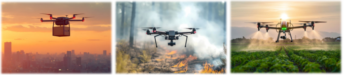
Drones, with their efficient and innovative solutions, have transformed the landscape of multiple industries. In the agricultural sector, drones facilitate precision agriculture, crop monitoring and livestock tracking. The industrial sector uses drones for on-site surveys, infrastructure inspections and project monitoring. Drones are still revolutionizing delivery services, especially in delivering packages, medical supplies and emergency aid to remote areas. This article will focus on the implementation of their systems.
The numerous applications of drones
1.Mapping unmanned aerial vehicle
This type of drone is equipped with high-resolution cameras and depth sensors, capable of creating detailed maps and 3D models for fields such as construction, mining and environmental monitoring.
2. Inspection drones
This type of drone uses thermal imagers and sensors to inspect infrastructure such as Bridges and pipelines, providing real-time data and detecting problems like cracks and corrosion.
3. Agricultural drones
This type of drone uses multispectral sensors to monitor the health of crops, manage irrigation, and spray pesticides or fertilizers, contributing to the development of precision agriculture.
4. Delivery drones
This type of drone is specifically designed for cargo transportation and is applicable to fields such as logistics, healthcare, and e-commerce, enabling rapid and efficient delivery services.
5. Monitoring and security drones
This type of drone is equipped with high-definition cameras and thermal imaging technology, capable of monitoring large areas and detecting intrusion behaviors, thereby enhancing security.
6. Heavy-duty unmanned aerial vehicles
This type of drone has excellent load-carrying capacity and can be used in the fields of construction, disaster relief and logistics to transport materials and equipment.
7. Environmental monitoring drones
This type of drone is used to monitor air and water quality, as well as wildlife populations, providing data support for research and conservation efforts.
8. Emergency response drones
It is used in emergency situations for transporting medical supplies, searching for survivors and assessing losses; Enhance the efficiency of rescue operations by leveraging thermal imagers and speakers.
9. Construction drones
This type of drone is used for on-site investigation, monitoring construction progress and conducting safety inspections. It can provide real-time data and high-resolution images, thereby achieving more efficient project management.
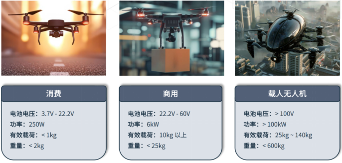
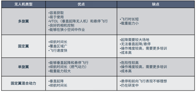
Classification of unmanned aircraft
Unmanned aerial vehicle autonomous navigation system
Image and depth sensors are indispensable parts of unmanned aerial vehicle (UAV) navigation systems, providing the key data needed for environmental perception and interaction for UAVs. Image sensors (such as high-resolution cameras) support visual navigation by detecting and tracking visual landmarks, which is particularly useful in environments without GPS. These sensors enable drones to identify obstacles, fly along designated routes, and make real-time navigation adjustments based on visual input.
The visual data captured by the image sensor is processed by advanced computer vision algorithms, enabling the drone to interpret complex scenes and make informed decisions. On the contrary, the depth sensor generates an accurate 3D map of the surrounding environment by emitting laser pulses and measuring the reflected signals.
This technology enables drones to precisely traverse complex terrains and avoid obstacles even in environments with insufficient light or severe visual interference. By integrating the data from image sensors and depth sensors through advanced sensor fusion technology, the situational awareness capability of unmanned aerial vehicles (UAVs) can be enhanced, enabling them to possess complex functions such as obstacle avoidance, precise navigation, and autonomous decision-making. The combination of vision and depth perception is crucial for drones to operate efficiently and reliably in diverse and challenging environments.
Gps-based navigation is another cornerstone of the unmanned aerial vehicle (UAV) navigation system. It uses the Global Positioning System to determine the precise position of the UAV and guide it to the pre-set route points. GPS can provide reliable positioning data, which is crucial for drones to maintain their course and accurately reach their destination in outdoor applications. The working principle of this system is to receive signals sent by multiple satellites and then determine the precise position of the unmanned aerial vehicle through triangulation.
However, in some environments, such as indoors, in thick forests, or in urban canyons where high-rise buildings block signals, GPS signals may be interfered with or not received at all. To overcome these limitations, GPS can be combined with other sensors such as image sensors and depth sensors to ensure that drones achieve continuous and precise navigation.
This hybrid navigation approach enables drones to seamlessly switch between different navigation methods, thereby enhancing their operational flexibility and reliability in various scenarios. By combining GPS data with real-time sensor input, drones can maintain precise positioning and navigation even in the presence of weak or lost GPS signals, ensuring continuous and stable operation in various environments.
Unmanned aerial vehicle perception system
When choosing an image sensor for a drone, it is essential to take into account the specific conditions and requirements of the application. Typically, a system may use six to eight sensors, but it is not uncommon to use as many as twelve sensors.
Global shutter sensors can capture the entire frame simultaneously and are highly suitable for shooting moving objects as they can prevent image distortion and motion artifacts. This is particularly important for applications with extremely high precision requirements such as surveying and mapping, exploration, and industrial inspection. By capturing the entire frame simultaneously, the global shutter can prevent common distortions such as the "jelly effect" and motion blur found in roller shutters.
·Low-power image sensors have multiple advantages. They consume less power and can be deployed in multiple locations, thus providing a comprehensive view of the scene.
·High dynamic range (HDR) cameras are crucial in drone technology, capable of capturing detailed, accurate and clear images under various lighting conditions. This camera can balance the exposure of light and dark areas, ensuring that no details are missed even in complex lighting conditions.
·High resolution: The 20-megapixel Hyperlux AR2020 will further enhance these capabilities, enabling inspection and surveying work to be carried out more meticulously and precisely.
· Expand the field of vision: With the SWIR image sensor, achieve observations beyond the visible light range.

| 免责声明: 本文章转自其它平台,并不代表本站观点及立场。若有侵权或异议,请联系我们删除。谢谢! Disclaimer: This article is reproduced from other platforms and does not represent the views or positions of this website. If there is any infringement or objection, please contact us to delete it. thank you! |

WeChat Official Account

WeChat Service
 Email
Email QQ
QQ 13823761625
